Lately I've been feeling like 2016 will be the summer that I become old. I've actually had several summers that sparked this emotion; the first one hit at age 19, so I know it's not necessarily an emotion I can trust. But between the reemergence of asthma symptoms — which I can no longer convince myself were a one-time illness; the carpal tunnel thing — which my surgeon speculated might be the culmination of an old wrist injury I don't even remember, possibly while snowboarding as an indestructible teenager; and an upcoming birthday that will place me squarely in my late 30s .... maybe I'm not "old," but definitely living in a deteriorating body. We all do, every day, but sometimes the realization hits us more directly.

This weekend my friend Leah was married in Portland, Oregon. I was excited to come out as she enters a new chapter of her life, and witness the swirl of emotions connected to this — as she put it, "all the feels." I also was looking forward to visiting Portland — a city where I was convinced I would live out my days, back when I was 19 and "old" but still indestructible — but never ended up moving here. In fact, the last time I even visited Portland was seven years ago when was in the midst of a difficult break-up. Admittedly many of my memories from this region have been cast in distinctly negative light.

Beat wasn't able to join, and the time I'd be able to spend with Leah was limited for obvious reasons, so this would be a solo trip to Portland. I decided I'd fill it with a bunch of hiking, as much as I could squeeze in between wedding activities. My flight out of Denver was at 6 a.m. Thursday, which required waking up after less than two hours of sleep to drive out to the airport in a sleepy daze, go through the cattle corrals for a one-stop flight through Seattle, then get stuck in an aisle seat directly across from the bathroom, which is just unbearable on a morning flight. By the time I was driving a rental car out to Cascade Locks, my head was in full jet lag mode even though I'd only traveled one time zone away. It was 11 a.m. but felt like midnight when I arrived at the base of the mountain I planned to climb — touted on multiple Web sites as the "hardest hike in the Columbia River Gorge" — Mount Defiance.
Imagine my disappointment when I found out the trailhead was under heavy construction and closed weekdays. I jogged along the I-84 corridor for more than four miles out and back, looking for a possible side route to poach. All I could find were cliffs and waterfalls.
Since it was still technically early in the afternoon, I got back in the car and drove all the way around the gorge to the Mount Hood corridor. I parked at an obscure wilderness area trailhead with a plan to hike a 13-mile loop to a 4,800-foot peak called ZigZag Mountain. There was no one else there, which is a little disconcerting on a beautiful pre-holiday-weekend afternoon so close to a large city. But I set out with a GPS track, headlamp, jacket, and emergency water purification tablets, which is all you need when heading into unknown woods by yourself.
Sea level wasn't quite the magic elixir for my lungs that I had hoped, so a bout of hard-charging running quickly turned to hiking. After that, I decided to keep it comfortable. Trail conditions started out runnable but soon deteriorated to an overgrown morass strewn with deadfall and toe-catching debris. My pace was much slower than expected, and the day was growing late. Once the route dropped off a secondary ridge and headed toward the summit, I had a difficult time locating the trail among the brush and deadfall. The GPS track, which I'd drawn myself based on a trail map, was not accurate at all. The loop was committing and I was inclined to turn around, but I was enjoying the views of Mount Hood and wildflowers. And anyway, I had a headlamp and water purification tablets.

The GPS track only became less reliable, and while the trail was still well-defined in spots, there were enough overgrown sections to throw me off. At one point I followed my GPS track too directly and ended up on top of a cliff, then had to backtrack until I found the trail. It was never a case of being lost or not knowing where I needed to go, but there was more route finding than I anticipated, and thus everything took longer. Finally, at about 7 p.m., I reached the Sandy River only to discover the trail bridge had washed away in a flood.
The river was roaring. I started hyperventilating. I'd walked twelve tough miles to reach this spot, it was late, and my only choices were to either cross the river or hike all the way back around in the dark on that hard-to-find trail. Of course, if I'd waited for the panic to subside, I would have remembered that I'd first crossed this river on a road bridge, which was only a mile away in a direct line, and could have bushwhacked through the woods following the river until I found it. Anyway, I let the panic subside and hiked along the river bank until I found a wide spot that was only about thigh deep, where the current was more gentle and I could see the bottom (these are all requirements of mine for crossing a river alone, a task of which I'm extremely frightened.)
I made it across without incident, but my adrenal glands were drained and I was so very tired. Only fear can make me feel this tired. Becoming lost and immersing myself in rushing water rank among my most pervasive fears. Sleep deprivation doesn't help. Still, once it was all over I decided ZigZag Mountain is a rewarding hike, a beautiful route and not as tough as I perceived. It was certainly secluded.

On Friday I was still pretty tired, but this was the only day I had completely free. Leah and I walked to get coffee in the morning, and she recommended I check out Silver Star Mountain. This 4,400-foot peak is at the edge of a big swath of wilderness in Southern Washington. I had to park about three miles from the trailhead because I didn't know the area required a recreation pass (this is what bugs me about online registration. What am I supposed to do as a tourist when I show up at a trailhead with no cell phone reception and no pass? Drive three miles down the road and park just outside the recreation area, I suppose.)
I spent most of the road jog/trail climb feeling pretty grumpy, but the summit ridge completely shifted my perspective. Leah was right. The views are amazing up here.
The sky was clear and Mount Rainier and Mount Saint Helens were in view, as well as Mount Adams, Mount Hood, and Mount Jefferson. I hunkered down and spent about 45 minutes on the summit, until I was shivering in the breeze.
Saturday was Leah's wedding. My original plan was to spend the day in the city and then head to the ceremony in the early evening. But I am who I am, so instead I set an alarm for 6 a.m., and by 7:45 I was back at the now-open Mount Defiance trailhead.
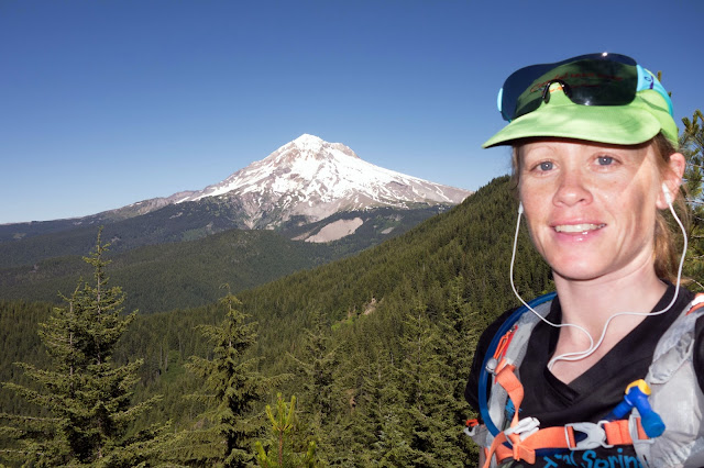
The reason Mount Defiance is touted as one of the toughest hikes in the region is because it gains 5,000 feet in 5.5 miles. But that's the worst of it. The Mount Defiance Trail is a good trail, winding upward through the trees in the cool morning mist with frequent glimpses of the Columbia River far below. I'm in my element in places like this, and because I'd already put eighteen hours on my feet for the week by Saturday morning, for the first time in a while, my legs were finally more tired than my lungs. This limited me to a hard but comfortable pace, with no wheezing or lightheadedness. I couldn't have felt more relaxed or content even though I was scaling a mountain.

The previous day, I was talking to Leah about the difficulty of finding flow. That's the one thing I miss most about riding bikes, because flow comes to me most effortlessly when I'm pedaling. Running and even hiking tend to cause more stress, and only rarely do I lose myself completely to the task. But I found flow on Mount Defiance, with my tired legs and happy lungs, marching upward through a loamy forest that reminded me of both Juneau and California, and helped me feel at home.
Mount Hood as seen from Mount Defiance. I again hunkered down on a rock, snacked on Goldfish crackers, reveled in this successful "defiance" of my sometimes broken, sometimes old body, and watched the clock in an effort to avoid being late for the whole reason I was in Oregon. It had taken me 2:45 to make the climb, and I fully expected to need at least three hours to get down.

I opted to return on a loop down the Starvation Ridge trail, which in hindsight I would not recommend. Although this route takes you along a rockier ridge with incredible views, then past a scenic lake, the final three miles are one of my versions of Hell. In this version, I'm standing directly over a place that I can see and really want to reach (in this case the I-84 corridor), but the only way to get there is a relentlessly steep slide of loose dirt, roots, and gravelly talus, and I can't stay on my feet. Even leaning forward and taking tiny steps, I slid onto my butt multiple times. After landing on my hand once and experiencing a horrifying shock of pain through my right wrist, I instinctively held it up every other time. No damage was done, but it was hard and frustrating.
What goes up must come down. This photo was taken at 1,200 feet, with more than a thousand feet to descend to the river. It looks like it's directly below, doesn't it? It is!
Still, I'm pleased that through it all I still made it to the summit of Mount Defiance. It was in many ways my own defiant victory, and a perhaps a preface to a new chapter of health and vitality. Leah's and Steven's wedding was great fun, although I was guiltily a little too tired to live it up. Congrats you two!