Last week, I joined my parents for our 11th trip to the Grand Canyon together. After 14 years, our tradition is still going strong, although there have been plenty of hiccups along the way. If it’s something you are considering and you’re new to it, you can find some
great deals on Grand Canyon trips online. It’s always a fun timeline to piece together:
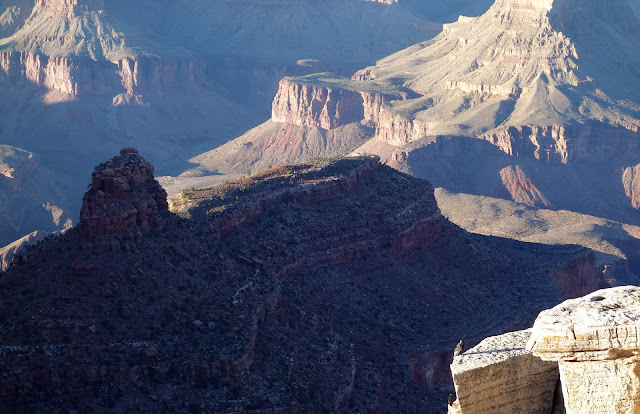
2004: North to South. One year after completing his first scorching rim-to-rim with a group of his colleagues, Dad decides to join a large group of family friends and neighbors for their annual traverse. He invites me. I'm a little skeptical because it's a long hike, and also because one of the young men the group was my elementary school tormentor (he teased me for being bad at sports, which I really was, and the teasing was probably not as bad as I remember.) Still, I am going to show him. It's brutally hot; the thermometer at Indian Gardens reads 113F. The scenery is jaw-dropping. My childhood bully is nice to me, a surprise, although we are 25 now, and I doubt he even remembers the playground taunting. I love the "lemmies" at Phantom Ranch. The climb out is not as bad as I expect. My legs are toast for several days. I'm hooked.
2005: North to South. Just a month after moving to Alaska, I fly down to Utah to join the group again.
2006: North to South. While negotiating a job contract with the Juneau Empire, I stipulate time off for my already planned trip to the Lower 48. My new boss agrees. Grand Canyon is officially a tradition.
2007: South to North. My aunt Jan joins us. She trained all summer. It's extremely difficult for her, but she perseveres. While climbing the North Kaibab Trail, temperatures plummet and the sky unleashes a spectacular deluge. Red waterfalls gush off sandstone walls, an impressive sight that becomes one of my favorite memories of this canyon.
2008: South to North. My first trip down the Kaibab Trail. We are joined by Dad's friend Tom.
2009: Missed because I couldn't get more time off work after my Tour Divide furlough.
2010: Missed to attend my grandfather's funeral.
2011: North to South. Temperatures are in the low 20s with a skiff of snow on the North Rim. It doesn't even hit 60 degrees at the river. Dad hikes his first rim-to-rim-to-rim. I had intended to join him, but then I accidentally overbook my weekend. So instead I rush back to the North Rim to grab my dad's 1994 Toyota pickup and drive that to Moab to pace my friend Danni for 50 miles in the Slickrock 100.
2012: South to North. We're joined by Dad's friend Chad and his wife Ophie. I'm one week off of finishing the Bear 100, and have to hike with my feet wrapped in tape because they're still badly blistered.
2013: Missed because of the Government Shutdown.
2014. Missed because of injury — recovering from a torn LCL I sustained in the Tor des Geants one month earlier. I still travel to the canyon with my parents and join my mom for the four-hour shuttle, hitting her favorite traditions along the way. It's a fun side of the trip I haven't experienced before.
2015: North to South to North. Finally, I complete a two-day rim-to-rim-to-rim with Dad.
2016: North to South to North. Beat joins for the first time, along with Dad's friend Raj, for the double.
2017: Missed because I managed to double-book a weekend again. I should really use a calendar. I feel intensely guilty about this.
2018:
Dad planned our trip early this year; the last week of September was the latest he could find rooms on the South Rim. On Wednesday, still deeply jet-lagged from Europe (jet lag always hits me so hard after the return trip, especially after a month of insomnia), I headed west toward Salt Lake City. From the first hour onward, I felt sort of terrible, but I hate to waste a commute through the mountains. I mean, how often can you pull off the Interstate you're driving anyway, park within 50 meters of the humming freeway, and walk up two 13,000-foot summits? My aim was Mount Parnassus and Bard Peak.
Beat caught a cold on the Sunday flight home, and by Tuesday I'd picked up the sore throat. My congestion wasn't too bad on Wednesday morning, but within a half mile I was wheezing with every labored step. Out loud I blamed the sickness and altitude, but quietly I felt certain this was evidence of the severity of my current fitness downswing. To top it off, the weather was
really cold. I'd just come from Switzerland, where temperatures still topped 80F, and it had been a warm September in the Alps overall. While hiking, I think I only wore a jacket twice for an entire month there. Here, my car thermometer registered 41 degrees at 10,000 feet, and the wind was howling. I'd almost forgotten about this crazy Continental Divide wind. How could I forget? I'd brought some warm things but not enough. I had no face mask, no shell pants, and only thin gloves. So from the start I was shivering and sick and increasingly grumpy. Plus, I was putting my Grand Canyon hike at risk by pushing through these conditions with a sore throat. Why did I do it? Sometimes ... most times ... I don't make sense to myself.
Topped out on Mount Parnassus, elevation 13,574. Windchill, -30? (Okay, it wasn't nearly that low. But "feels like" matters for something.) Despite the wheezing and plodding, I made okay time to the peak, and Bard was
right over there and it seems a shame not to go now that I'm here. It's not like I even really care. I'm never going to go for all of the Colorado Bicentennials or adopt any other goal that makes it matter whether I tag a peak or not. But I can be so stubborn. So I dropped into the crumbly traverse along the ridge, balancing atop loose boulders on a steep side slope. This traverse was much slower than climbing the tundra ramp to Parnassus. By the time I reached the saddle, I knew I was looking at an extra two hours at least, and regretted my decision. But I was committed.

The climb to Bard Peak, from 12,800 feet to 13,641 feet, finished me off. My sinuses filled with mucous and I was done. But I still had to re-gain Parnassus. It was awful. The kind of effort that left me pausing after every four steps to catch my breath so I'd stop feeling so dizzy. The kind of desperation that caused somewhat uncharacteristic involuntary swearing, f&*@ me. When I wavered, the endless skyline of the Continental Divide stood steady, taunting me. I hated feeling so unfit and close to helpless, and lashed out with anger. "Ugly Colorado mountains, look like @&$! piles of dirt," a surprisingly venomous exclamation that instantly caused me to laugh out loud. Ha, I don't believe that. People who don't care about mountains might believe that. European Alps snobs probably believe that. But not me. I love these mountains, in all of their late-autumn beige grandeur. It's not the mountains' fault that I feel like a pile of dirt.

"Yes, I will blame the altitude and cold," I thought as I continued west on I-70, pretending I was no worse for the wear. The following day, the three of us and my Dad's friend Chad made our way south. Around 3 p.m., we stepped out of the car to gaze over Glen Canyon Dam, where we were hit with the searing 90-degree air of Page, Arizona. I'd been napping (felt like midnight to me), and this hot air was just as shocking as the frigid windchill on Mount Parnassus. Temperatures for the canyon were forecast to be in the high 90s the following day. Dad guessed it would be our hottest trip across the canyon since the first, in 2004.
Still, we enjoyed a lovely evening on the South Rim, where even after sunset, it was so warm we could walk along the rim in our T-Shirts. We also spotted a California condor as it soared through the air above us and landed on a perch next to the yawning void. Without a telephoto lens, I couldn't capture much of a photo. But we conferred with folks around us, looked at the bird from multiple angles, compared its features to a photo on a plaque that just happened to be right there, and are quite certain it was a condor. Very cool.
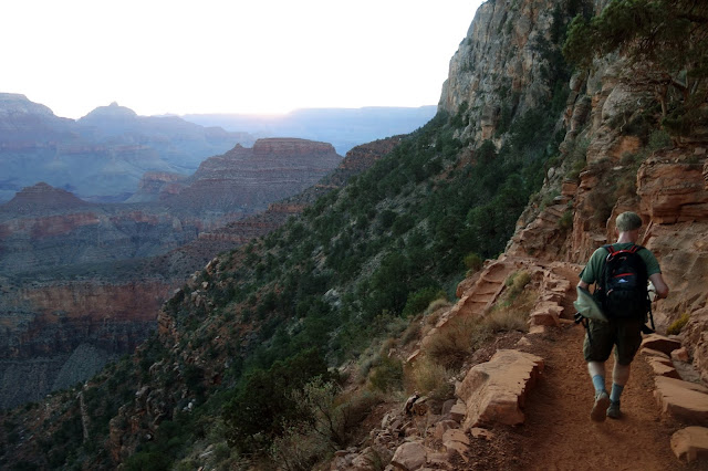
Dad, Chad and I set out at dawn from the South Kaibab trailhead. I'd given Dad some warning about my potentially poor condition by describing my hike two days earlier as "a lot of huffing and puffing." Here at 7,000 feet, I did feel significantly better, although the sore throat and congestion were still bothering me. Chad has been injured and didn't think he was in the best condition, so I hoped for an easy-going day where no one would notice I was in such terrible shape.
I do love the morning light on the South Kaibab. I felt at peace. I know this canyon. I'm comfortable here. There's little left that seems especially difficult or scary, but I should know better to expect the unexpected.
Crossing the Colorado River on the "Black Bridge." The suspension bridge was built in 1928, with men using spotlights and working through the night to avoid the heat of the day. Members of the Havasupai tribe carried the one-ton suspension cables down on their own backs. "Those were the days of hard men," Dad observed. The plaque didn't mention that the men doing the heavy-lifting were Natives. I had to look up Wikipedia for that information.
Temperatures did rise into the high-90s down in the canyon, but our timing was ideal. We wound through the box canyon in the waning shadows of morning, and climbed steeply along the canyon walls with the shade of afternoon. We only had to endure full exposure to the hot, hot sun for about five miles in the middle. Dad set a rapid place, and I surprised myself by more or less keeping up. I suppose lower altitudes do help my breathing.

Looking toward Ribbon Falls. Chad, who was feeling the sting of his plantar fasciitus, decided the skip the side trip to the waterfall. Dad and I agreed long ago that we'd never pass up a chance to see Ribbon Falls up close — after all, how often can you pull off a trail you're hiking anyway and sit beside a ribbon of bright green moss and cascading water in the desert? It seemed everyone else in the vicinity had the same idea. Although we saw relatively few people in the canyon on this hot Friday in September, there were more than a dozen folks at the falls, all wedged into a tiny slice of shade still available at high noon. We took extra time to crawl to an more open spot in the shade, and then had a group of three women come and plop down right between us. One woman set her poles down on top of my Dad's shoes, with his feet in those shoes. Another took off her pack and looked for a spot to set it down. She kept looking back at me expectantly, as though waiting for me to move so she could place her pack where I was sitting. Lady, I am not going to move for you. But we did cram down the rest of our lunch quickly so we could escape to freedom.

With sweat streaming down arms and legs, we climbed to the Cottonwood campground and pulled off our now-light packs. We planned to fill up our water here, as we have for more than a decade through this canyon. We turned on the spigot and ... nothing. Dry as a bone. A man nearby told us the water was off ... pipeline broke, he said, didn't you see the signs? We traveled here from the South Rim; we saw no such signs. Yeah, the man replied, no water, all the way to the top.

No water? For seven miles and more than 4,000 feet of climbing that remained? I nearly always hike with a small filter, but I purposely left it behind for this trip, because I anticipated heavy sweating and wanted to keep my small pack as loose as possible, and also because the piped water in this canyon has always been reliable. Dad and I both carried purification tablets — I actually only had enough to make two liters, with chlorine tablets that carry a recommended four-hour activation period. We were walking past the campground, complaining loudly about this, when man with a thick Canadian accent yelled from a hundred meters away. "Hey, you need to borrow a filter?"
The Canadians were from Prince George. "The far north," one said. Just as I was thinking, "I have friends from the Yukon who would probably disagree with you," he continued, "Not really. Everyone just thinks that because we're in the middle of nowhere." They had a brand new MSR filter, never before used because in British Columbia, they just drink directly from streams. Dad and I took it down to Bright Angel Creek and pumped five liters of water. As we worked, the nice young man came down and chatted with us. I told them about my drives up and down the Cassiar. He talked of his past trips to the Grand Canyon. "You guys are all right," Dad said.

We again caught up with Chad at Manzanita. He had waited for us there for nearly an hour, worried that we hadn't found water. He'd treated his own with iodine. The normally bustling rest stop was more or less a ghost town. No one cares to hang out where there is no water. Dad set a brisk pace for the final steep climb, five miles that always seem to go on forever. My congestion was building again, but my breathing was okay. It's impossible not to enjoy this section, carved into sheer sandstone up a seemingly impenetrable blockade of canyon walls. My legs felt especially heavy, and I decided that wading through this ankle deep sand — mule traffic erosion — was harder than hiking in the Alps. Dad didn't seem fazed.

Our first warning sign — at the trailhead, at the very end of our hike. I wondered how many other rim-to-rim hikers and runners were caught off guard by this. It's no small thing to go 14 miles uphill on a 90-plus-degree afternoon without water you'd been expecting. It would have been a small problem for us had we not met those nice Canadians.
But we banged another one out. This was my 10th year across the Grand Canyon with Dad. Eleventh trip, counting 2014. And twelfth crossing together, factoring in our two double-crossings. Dad is 65 now. I believe he's holding up his Medicare card for a fun photo op here. He only gets better with age. I get worse, but Dad gives me hope that the best years are still ahead.
Having nowhere to stay on the North Rim, we decided to drive all the way to Salt Lake that evening. A bit brutal, traveling eight hours in a car after a 24-mile hike, but the drive home had its own magic. We saw a bison herd on the Kaibab Plateau.
The aspens were brilliant, and appeared near peak. We're usually here two weeks later, after the brightest leaves have dropped.
Arizona sunset. Does any other state have better sunsets? I have yet to see evidence to the contrary.
By Saturday morning, I was definitely sick. I had a "man cold," which is distinguished from a regular cold because you complain about it significantly more. Dad invited me out for a run and I turned him down. My 65-year-old father, still spry as can be after a rim-to-rim traverse, and I'm laying around in bed. I did have a chance to visit my grandmother, who is on hospice, so there's always that expectation that this visit may be the last. I was grateful for that opportunity. On Sunday, I headed home on Interstate 80.

I was feeling a little better. And since I was in Wyoming anyway, I decided to detour on the scenic route over Snowy Range Pass. While I'm at it, why not climb Medicine Bow Peak? The nearby Ryan fire had recently flared up, and the southern horizon was obscured with smoke, but overhead skies were clear. I couldn't smell anything anyway, so I just had to assume the air was okay. It was still quite hot — 72 degrees at 10,000 feet. The wind also was raging, but it was more of a blow-dryer wind, hopefully not blowing undetected smoke into my lungs.
I could barely breathe through my congestion. I went through an entire portable pack of tissues, and still failed to stem the steady flow of snot. My head was pounding, too. This man cold had not yet retreated. But unlike Wednesday, I was not a grumpy pants about it. The afternoon light was gorgeous and I was enjoying the wide-open landscapes of southern Wyoming. Clearly the Grand Canyon had healed my heart, just a little bit, yet again.
I was a little disappointed about how poorly I was breathing at 10,000 feet. But the boulder-strewn summit of Medicine Bow Peak is actually 12,013 feet, so that's probably okay.
Beyond the peak, three miles of wide-open ridge walking took me through a richly lit moonscape that I had all to myself.
Looking down at Lake Marie through the imposing gullies surrounding it.
Although I really was sick and probably should have taken it easier, it was satisfying to hike in three states, over high mountains and through deep canyons, in the span of fewer than five days. It was a needed "welcome home" for my soul.