It started, as many mountain binges do, with a sudden and almost crushing sense of urgency on a Sunday night. It may have been 90 degrees. The sky may have been filled with the smoke of the first and sixth largest fires in Colorado history — and dozens more throughout the west. But it was also the end of August. September was coming, and with it, that time when mountain access tightens and any adventure dreams that linger on this wilted weed of a summer will be crushed.

My wishes for the rest of this summer mostly reside in Rocky Mountain National Park. Before this year, the crowded park held only passing interest, mostly in the spring when I could ride my bike on still-closed roads. Then the pandemic brought crowd-reducing restrictions as the hoards funneled everywhere else, and paradoxically the national park became a place to seek solitude. Vying for timed entry permits became a fun game, and I felt compelled to stick by the dates that I "won." The more I visited, the more intrigued I become. Now I've had little tastes of the glacier-carved valleys, the alpine lakes, the soaring spires and tumbling streams, I want to experience everything I can of this well-loved gem.

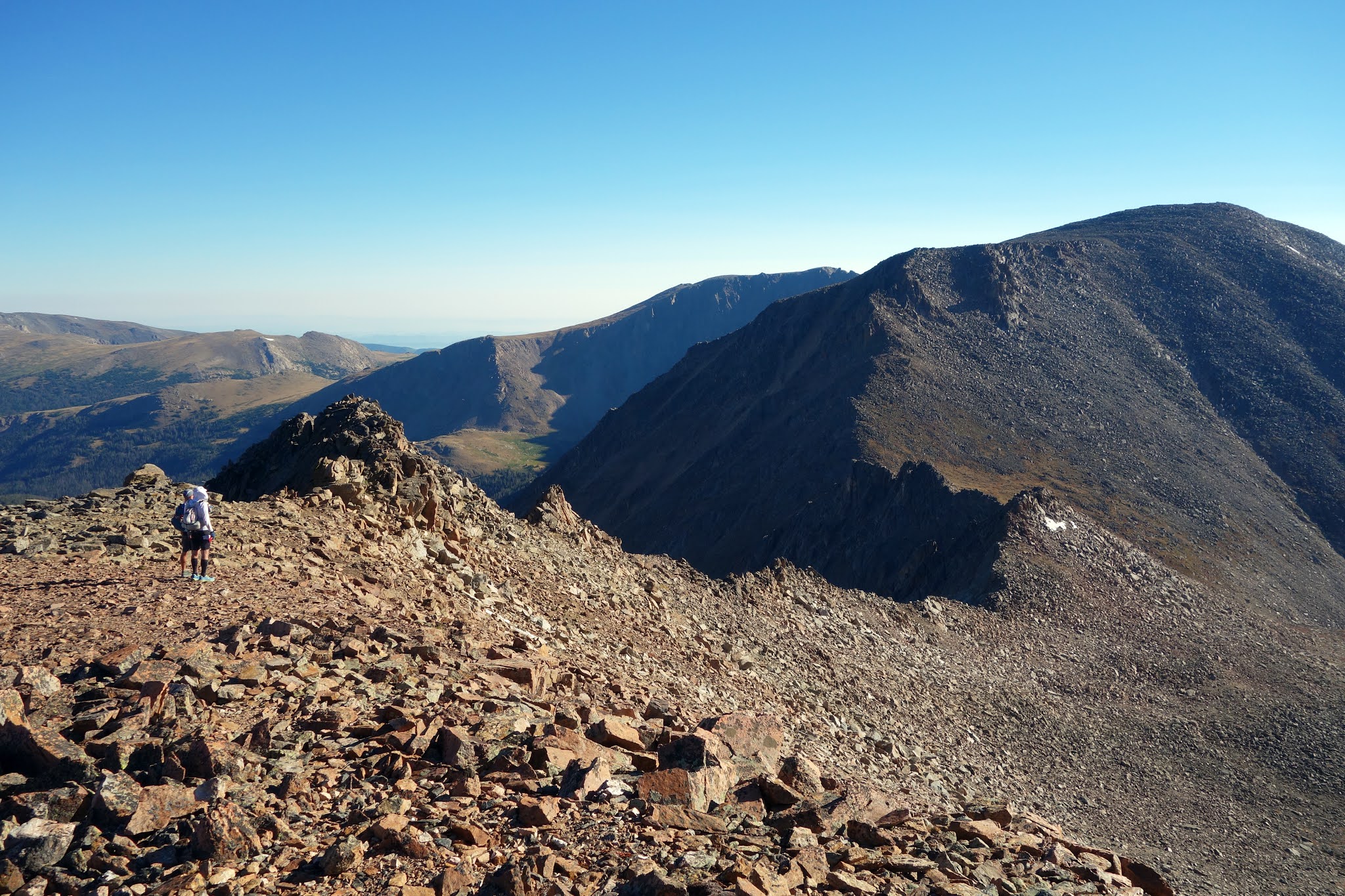
On Monday I planned a relatively mellow morning hike to The Saddle (yes, proper noun) above Lawn Lake — a good spot to climb above treeline and soak in nice views before afternoon weather moved in. The air quality wasn't great, but it wasn't the worst it's been. As these weeks of wildfire drag on, I've grown complacent about smoke, accepting the wheezing, coughing, sore throat and probable long-term health effects as the cost of living my best life (not unlike the COVID-deniers, I suppose.) But on this morning I was feeling quite good. The morning air was almost cool, and I enjoyed the solitude, passing only two other hikers as I climbed along the Roaring River gorge. Eight lovely and lonely miles later, I was standing at The Saddle, viewing hazy but decidedly clear skies to the west, and the enticing summit of Hagues Peak to the north.

Hagues, a 13,560-foot summit and the highest in the Mummy Range, has been on my list for some time. Truthfully, all of the 13ers in this region are on that list, but Hagues is one I'd researched enough to feel intimidated by its ascent route, which is rated class four in some reports. Indeed, its south ridge looks intimidating, but the weather was amenable and I had no reason not to check it out. A west wind was howling, so I tightened shoelaces and backpack straps before starting up. As I picked my way along the boulders, gusts threw me off my line and nervous energy gnawed at my gut. This energy-draining fear forced me into a sort of autopilot, breathing and crawling, solving this mountain puzzle rock by rock. The strenuous physical effort went almost unnoticed until suddenly I was hoisting my shoulders over a slab and looking toward a weather station on the summit. I just climbed Hagues! Alone! Even as I become more wobbly and nervous with each passing year, I still have some modicum of mountain conqueror left in me, I thought.
Of course, the wind intensified during the descent. A forceful gust finally knocked me off my feet, and I slammed a shin into the edge of a table-sized boulder. Shin hits are the worst. I always find myself laying on my back with tears in my eyes, convinced this is the one that finally broke a tibia. By and by the pain subsides, but I then have some nine miles and 5,000 feet of vertical descent to limp home. I feel like I'm suffering so much, but it only takes a day before the pain has become almost a distant memory. There's so little flesh on the shin to bruise that pain doesn't linger. So weird, this injury.

Hagues was my opportunity to scout the crux of the Mummy Traverse, a long-time bucket list item that I considered possibly beyond my scope. Known as Mummy Mania in hiking circles, the traverse is an opportunity to bag an entire mountain range in one day, summiting the seven 13ers and one 12er that compose the spine of the Mummy Range. The one-way, 19-mile route hovers above 12,000 feet for more than 15 miles. All of those alpine miles are off-trail, with varying degrees of talus scrambling. Even in its downhill direction, the one-way traverse requires more than 6,000 feet of climbing. It sounded hard but spectacular. Friday presented an ideal weather window, which one needs when spending an entire day above treeline with no easy escape routes. Beat and I recruited our friend Daniel to join us.

We hit the trail off of Old Fall River Road a little before 6 a.m., still dark this time of year. We rose with the sun to the summit of Mount Chapin, a "bonus" 12er that's easy enough to bypass, but why skip any summit?
The light was lovely, and I enjoyed watching the moon set over distant peaks. We had to wake up at 3:30 a.m. to make our day's timeline. While I relish opportunities to see the world wrapped in the mysteries of morning, I admit that I won't miss these early alarms when mountain season is over.
From the first 13er, Chaquita, we could see a line of just a few the day's objectives: Ypsilon, Fairchild and Mummy. They looked so close, and so far away.
The traverse to Ypsilon was mostly nice tundra walking, which gave us opportunities to gaze over ledges and through peek-a-boo couloirs to the spectacular ridges and lakes below.

After Ypsilon, the difficulties began. Our next objective was Fairchild — one mile and a minefield of uneven and often loose talus in front of us. This is the type of terrain that yields 90-minute miles at zone-four efforts, is as strenuous descending as it is climbing, and often results in sore shoulders and bruised knees. I'd linked these two peaks before, in the opposite direction on my birthday in 2018. Even though it was two years ago, I surprised myself by remembering the fine details of the traverse. I proudly recited my route knowledge to Daniel and Beat: Cut straight down to the tundra, where the rocks are more stable. Climb toward that U-shaped gully, hugging the middle ridge. My 2018 birthday hike had pressed so sharply into my memory that I could see every part of it. I shuddered when I remembered the loose boulder that shifted underneath my feet and caused me to stumble into another one of those imaginary tibia fractures. I remembered the fear of feeling incapacitated while high and alone on a mountain, wondering if I might not live past the exact age of 39. It's not always pleasant, but I cherish these intense and enduring memories. It's why I continued to pursue hard things. Memories of comfort and familiarity are too easily lost to time.
 |
| Photo by Daniel Benhammou |
The boulder-crawling proceeded slowly but steadily — me being the slow one, of course. Daniel could hopscotch this stuff if he were alone, and Beat falls somewhere in the middle of abilities. I can only protect shins and skull by maintaining hand contact, viewing the mountain as a kind of chaotic jungle gym. As I crawled along, we noticed a dark figure high on the ridge above us. It was moving its head back and forth, so we could see it was an animal but couldn't identify what it was. At first, we thought it was a dog. But we had seen no humans all morning, and it was a strange spot for a dog to be alone. It was far too large to be a marmot. On closer inspection, I noticed rounded ears and a light snout. "It's a bear!" I yelled. But even I didn't believe this. What bear climbs to 13,000 feet to sunbathe on a boulder? Finally, we convinced ourselves it was an optical illusion that made a marmot look enormous.
Daniel decided to add some spice to his ascent by scrambling along the ridge as Beat and I continued up the gully. A few minutes later, he yelled to us that it was definitely a bear and it had scampered away from him in our direction. I spent the rest of the ascent calling out "Hey Bear!" from time to time, in case it lurked in crevices. What was a black bear doing thousands of feet above food and water sources? We speculated that it may have been a refugee displaced by the nearby Cameron Peak Fire, and was making its way to the safety of another valley.
We took what felt like my only break of the day on top of Fairchild Mountain. As the slow person in a group with a tight timeline, I had to stay on the move just to keep up. I brought six half-sandwiches to eat over the day, and this was the only one I nibbled while sitting down. The rest I had to cram into my mouth between handfuls of rock and rubble.

We crawled down Fairchild to The Saddle, for an intimidating view of our next objective, Hagues. I again felt full of confidence since I'd just climbed this peak four days earlier, and explained the route to Beat and Daniel.
Strangely, as we neared the class-three scramble to the summit, I couldn't surmise where to go. The route had seemed so obvious on Monday, but the fatigue of Friday cast a shroud over my memory. Funny, because my memories were so sharp for Fairchild, even though they were two years old. "You were just here four days ago," Beat said, exasperated, as I mumbled and bumbled while gazing at the walls towering overhead.
We scrambled up a few boulders, and there I spotted the ramp that I definitely did remember. "This is it," I called out to them. "You go around the walls. To the left. Then hook right."
 |
| Photo by Daniel Benhammou |
And with that, we found the final scramble to the summit as Fairchild loomed behind us.
Hagues had intimidated me for years, and then I climbed it twice in one week. I was chuffed about this.
From Hagues, we descended off the ridge for a couple of bonus mountains — off-route slightly, but still part of the range, and still 13ers. Rowe Mountain is a relatively diminutive peak over Rowe Glacier and Rowe Lake, which is supposedly the second-highest lake in North America at 13,100 feet. The highest lake is also in Colorado, near Breckenridge.
Rowe may be small, but its boulders are big. I was growing deeply fatigued, mentally more than anything else. None of this stuff comes naturally to me, and maintaining the level of concentration it takes just to remain upright is so much harder than any physical endeavor I've tried. Perhaps even harder than dragging a sled.
We made our way along the ridge to Gibraltar Mountain, where I grabbed another opportunity to sit down for one minute and 40 seconds to eat my sandwich (so two breaks. I got two breaks.) We watched a patch of the Cameron Peak Fire flare dramatically, right before our eyes. Within minutes, this plume of smoke was blowing directly in our faces, and my breathing suddenly became strained. I took a few inhaler puffs but held off on putting on my KN95 mask — reducing oxygen needed for concentration at 13,000 feet was undesirable until absolutely necessary. As I stood up, I immediately caught my toe on a boulder and toppled forward, bashing the same shin I crushed on Monday, as well as my knee. I was so embarrassed, but I had no choice but to writhe on the ground for several minutes until I stopped seeing stars. I knew I was okay. I'm always okay. And luckily, when it comes to mountaineering, I don't have much of an ego to bruise.

The adrenaline rush from the fall may have been a worse blow. After it faded, I felt close to flattened. We were lucky that the smoke plume mostly held to the ridge along Rowe and Gibraltar, so once we dropped back into the bowl and began the climb toward Mummy, we were clear of it. But the wheezing continued, and my vision flickered. The talus along Mummy was some of the worst, ranging from television-sized to car-sized, and much of it was loose and unbalanced. For a seeming eternity, I oozed along rocks at my 90-minute-mile pace, gasping as though I was running a marathon. Everyone was struggling. Even Daniel complained of headaches. I speculated that ten hours above 12,000 feet had hit all of us in our own unique ways. These alpine zones are a paradox. They're desolate places, and yet we come here to feel alive. The persistent oxygen deprivation causes fatigue and, for me, a strange sort of despondency. But later, when oxygen levels are restored and the desperate moments fade in memory, all that remains is soaring joy.
I was completely winded for the final ascent to Mummy Mountain. The haze seemed to seep into both body and mind, searing my lungs and obscuring my thoughts. But the views were incredible. I felt grateful that, despite all, my body still allows me to climb to these heights.
From Mummy, we made the long descent down a tundra ramp to the Roaring River valley. We stopped to filter water, having spent the entire day nursing three liters after discovering that Rowe Lake had no outlet stream, and feeling too lazy to climb to the lake. I suppose this counts as another break, so that makes three breaks. We all sat for a seemingly long while, five minutes at least, sipping from filter bottles and gazing up-canyon with glassy-eyed stares. This was a hard day for me. My hardest, by far, since I stepped off the Iditarod Trail in March. We still had six miles to travel to the trailhead, and Daniel and Beat insisted on hiking it at a 15-minute-mile pace while I jogged desperately behind them. My shin hurt. I was exhausted. But as the oxygen-rich forest closed in around me and the sun sank below the western horizon, I started to feel giddy. The Mummy Traverse! I actually did it!

Arriving at the trailhead didn't end our adventure, as we still had to complete the vehicle shuttle. The three of us donned masks for our shared indoor time. Daniel drove his Tesla up the narrow dirt road, where we encountered two enormous bull elk that refused to yield. The standoff lasted for ten minutes, at least, as the last hints of twilight faded. Honking didn't work, and neither did flashing lights. We didn't want to harass the animals, and Daniel didn't want to risk challenging them with his nice car, so we sat. Finally, Daniel got frustrated, stepped out of the car, and tossed small pebbles their way. This also didn't work. It was starting to seem absurd, especially after 13.5 hours on mountains where bear encounters outnumbered human encounters. We could only laugh. Eventually, the elk got bored with us and sauntered up the hill. We could finally return to our own car and the exhausting two-hour drive around Trail Ridge Road and home.

As we languished in recovery on Saturday and my shin continued to throb, it became apparent that the mountain season really might close in on us abruptly. It was the hottest day of the year, and the hottest day we've seen at home in four years of living at 7,200 feet — 95.3 degrees. The Cameron Peak Fire exploded, nearly tripling in size to a staggering 99,000 acres in fewer than 48 hours. I felt grateful that the Fairchild-summiting black bear escaped when it did, just before the fire crossed the northern perimeter of the park and smoke poured over the Mummy Range. But the apocalyptic conditions were tempered by something even stranger — a summer winter storm warning, starting Tuesday. Forecasters speculated this strong cold front could dump more than two feet of snow on summits that were currently shrouded in smoke and so warm that one could nap comfortably in a T-shirt at 13,000 feet. But two feet of snow in September might just be enough to linger. It might just be enough to close down the harder summits for the season.

For Sunday, it was settled. We were going to go for Chief's Head, the third-highest peak in the park at 13,579 feet. Beat wanted to tag Mount Alice for good measure. If we were successful, that would mean tagging ten 13ers in one week — if I count Hagues twice, which I absolutely do.
At least two dozen cars had crowded into the Wild Basin parking lot when we showed up at 5:30 a.m. But once we hit the trail with headlamps in the predawn darkness, we saw nobody else for the entire ascent. As usual, the once-intense pain in my shin had faded, revealing a colorful bruise and more persistent pain in the knee I'd also bashed in Friday's fall. But all was manageable. Air quality was refreshingly okay, which was surprising given our proximity to the Cameron Peak Fire. Flame-fanning winds blew due east, and we were just far enough south to miss the plume.
We made quick work to the saddle while admiring the spectacular peaks of Glacier Gorge. Powell and McHenrys Peak seem impossible to me now. But who knows. Maybe someday.
The climb to Chief's Head was another exhausting boulder crawl. Near the summit, the ridge suddenly pinched in. I'd been so engaged in the work of strenuous puzzle-solving and protecting my sore leg that I didn't notice until I glanced left to an expanse of empty space reaching 2,000 feet into Glacier Gorge, and right to a similar abyss over the Lion Lakes. Vertigo clamped down, and I found myself teetering and stumbling as dizziness rattled my perspective. This is endlessly annoying to me — that exposure prompts my brain to react in a way that scrambles motor functions and causes me to become even less competent than my already wobbly baseline. Sharp focus and steadiness is what I need, brain. Fear helps nobody.
Beat slowed to help coach me over a few tricky spots. They were all class three, no true exposure — if I fell, I probably would have bashed a shin, nothing more. But the cliffs just a few feet to the left pulled at my brain like a magnet. For emotional purposes, I might as well have been dangling my feet directly over the ledge. Finally, we reached the summit, and I was stoked. The abyss continued to pull at me. I badly wanted to sidle up to the ledge and look down at a half-mile of pure space ending at Green Lake. The thought was thrilling, but my brain wouldn't allow it. My entire upper body froze and I knelt down, shivering with dizziness. It did not seem prudent to let my vertigo become worse when I still had to scoot myself down the mountain. So I settled for a solid perch and views of Pagoda, Longs and Meeker.

From my safe spot, I could see other lovely lakes that I remembered fondly from my Glacier Gorge explorations a few weeks earlier. I could even see Lake Solitude, which I'd accessed by way of a brutally steep and mostly secret route winding through the cliffs. The little tarn was nestled in a granite hollow far below, sparkling in the sunlight.
Beat and I agreed that Chief's Head had the best views of any peak in this region. He thought they were even better than Longs, which has such a broad summit that one can only see in one direction at any given time. From the narrow spine of Chief's Head, we could look east along the ridge and down into Wild Basin, south to the Continental Divide and Indian Peaks wilderness, west to the peaceful valleys where we backpacked the previous week and down into Grand Lake, and north to the Mummy Range and Cameron Peak smoke plume. "You can see all of Rocky Mountain National Park up here," I observed.
As we started down toward Mount Alice, I noticed that my legs felt significantly wobblier than before. I reminded my brain that "this is a huge, wide ridge. You can't fall." But dizziness persisted. Adrenaline had drained my last reserves of quick energy, and the rest of this day was going to be about maintenance and survival.
 |
Photo by Beat Jegerlehner
|
Decision-making also seemed compromised. I picked a particularly poor line down Chief's Head, seemingly finding every loose boulder on which to teeter and gasp as I panic-shifted my weight to regain balance. I was feeling downright embarrassed about my difficulties, especially after we encountered two runners on top of Chief's Head who were making their way along a truly difficult ridge traverse from Glacier Gorge. Wearing shorts and tiny packs, they scampered away to the tackle Pagoda's knife ridge. I was awed but still felt forced to look away as they leaped over rocks toward the abyss, as breezily as children playing hopscotch. Bah, vertigo annoys me so much. But what can I do? Hypnosis, maybe. Of course, is it really beneficial to remove one's fear of gravity? When you're as clumsy as I am even on easy terrain ... probably not.
The descent off of Chief's Head was hard, but the ascent to Alice just about killed me. Hourglass Ridge looks almost vertical from the saddle, and indeed it gains a thousand vertical feet in almost no horizontal distance. While picking my way up the rocks, my watch only recorded 0.03 miles ... although I was moving so slowly that it probably just registered a full stop.
 |
Photo by Beat Jegerlehner
|
I mostly stopped taking photos at this point, but Beat got some nice ones.
 |
Photo by Beat Jegerlenher
|
High in the mountains, deep in the pain cave. Behind is the south face of Chief's Head and more distant summits of Longs and Meeker. From the saddle, we spotted two other runners about a quarter-mile behind us. Beat was sure they would pass us, but they took one look at the face of Alice and beat a quick retreat. At least that was how I interpreted their motions as they traversed the entire saddle only to turn around.
I was fairly blown out by the time I reached Mount Alice and wasn't as awed by the views as I had been on Chief's Head. I could only sit and cram down a peanut butter sandwich (an entire one, this time. I needed it) and look in disgust toward the Cameron Peak Fire smoke plume. Views of the Mummys were almost completely obscured, and pyrocumulus clouds mushroomed over the haze. Beat and I agreed we were lucky we attempted the Mummy Traverse when we did. With this northern part of the park, including Trail Ridge Road and Old Fall River Road, now closed, and a verglas-forming storm on the way, it may have been the last day of the year it was accessible to us.
 |
Photo by Beat Jegerlehner
|
I was grateful for these narrow windows to crush ten 13ers in one week, but I feared Alice may have been one mountain too many. "It's all downhill from here," Beat assured me, but I knew there was a lot of downhill ahead. All of the hard parts, really. I stumbled down the tundra below Alice, failing to get my cheap audiobook player to work and feeling so frustrated about it that I almost cried. And that was before we had to descend the choss of Boulder Grand Pass, which Beat and I agreed should be renamed "Windy Shitty Pass." The west wind was howling, nearly blowing both of us over as we slipped and slid over pebbles and sand.
 |
Photo by Beat Jegerlehner
|
We reached the Lake of Many Winds, which was significantly shallower than it had been just a few weeks ago. Still, the lovely blue water shimmered and swirled amid the many winds. Beat was in a great mood, truly in his element on the far end of miles of talus-hopping. He could have climbed another ten mountains given the opportunity, and indeed that's what he would have been doing in this very moment of this had turned out to be a normal year, and we were in Italy for the Tor des Glaciers.
 |
Photo by Beat Jegerlehner
|
As for me, nothing about this sort of mountain travel falls in my element, with the significant exception of desire. Desire is so strong that I'm willing to overlook every other ridiculous side to it, from my sheer lack of talent for technical terrain (A few days earlier Beat made a joke about calling me Wobbles, which I figure will be my trail name if I ever attempt a thru-hike), to the heat and smoke and oxygen-deprivation that flatten the one talent I do have, which is endurance. But it's worth it. As we descended into the apocalyptic brown cloud that was choking the Front Range, I felt both grumpy and elated. Mountains are a true paradox, and it's this dynamic that makes them so compelling.


 The light was lovely, and I enjoyed watching the moon set over distant peaks. We had to wake up at 3:30 a.m. to make our day's timeline. While I relish opportunities to see the world wrapped in the mysteries of morning, I admit that I won't miss these early alarms when mountain season is over.
  From the first 13er, Chaquita, we could see a line of just a few the day's objectives: Ypsilon, Fairchild and Mummy. They looked so close, and so far away.
  The traverse to Ypsilon was mostly nice tundra walking, which gave us opportunities to gaze over ledges and through peek-a-boo couloirs to the spectacular ridges and lakes below.
  Strangely, as we neared the class-three scramble to the summit, I couldn't surmise where to go. The route had seemed so obvious on Monday, but the fatigue of Friday cast a shroud over my memory. Funny, because my memories were so sharp for Fairchild, even though they were two years old. "You were just here four days ago," Beat said, exasperated, as I mumbled and bumbled while gazing at the walls towering overhead.
 We scrambled up a few boulders, and there I spotted the ramp that I definitely did remember. "This is it," I called out to them. "You go around the walls. To the left. Then hook right."


 We took what felt like my only break of the day on top of Fairchild Mountain. As the slow person in a group with a tight timeline, I had to stay on the move just to keep up. I brought six half-sandwiches to eat over the day, and this was the only one I nibbled while sitting down. The rest I had to cram into my mouth between handfuls of rock and rubble.


 Hagues had intimidated me for years, and then I climbed it twice in one week. I was chuffed about this.
  From Hagues, we descended off the ridge for a couple of bonus mountains — off-route slightly, but still part of the range, and still 13ers. Rowe Mountain is a relatively diminutive peak over Rowe Glacier and Rowe Lake, which is supposedly the second-highest lake in North America at 13,100 feet. The highest lake is also in Colorado, near Breckenridge.
  Rowe may be small, but its boulders are big. I was growing deeply fatigued, mentally more than anything else. None of this stuff comes naturally to me, and maintaining the level of concentration it takes just to remain upright is so much harder than any physical endeavor I've tried. Perhaps even harder than dragging a sled.
  We made our way along the ridge to Gibraltar Mountain, where I grabbed another opportunity to sit down for one minute and 40 seconds to eat my sandwich (so two breaks. I got two breaks.) We watched a patch of the Cameron Peak Fire flare dramatically, right before our eyes. Within minutes, this plume of smoke was blowing directly in our faces, and my breathing suddenly became strained. I took a few inhaler puffs but held off on putting on my KN95 mask — reducing oxygen needed for concentration at 13,000 feet was undesirable until absolutely necessary. As I stood up, I immediately caught my toe on a boulder and toppled forward, bashing the same shin I crushed on Monday, as well as my knee. I was so embarrassed, but I had no choice but to writhe on the ground for several minutes until I stopped seeing stars. I knew I was okay. I'm always okay. And luckily, when it comes to mountaineering, I don't have much of an ego to bruise.
  I was completely winded for the final ascent to Mummy Mountain. The haze seemed to seep into both body and mind, searing my lungs and obscuring my thoughts. But the views were incredible. I felt grateful that, despite all, my body still allows me to climb to these heights.
  From Mummy, we made the long descent down a tundra ramp to the Roaring River valley. We stopped to filter water, having spent the entire day nursing three liters after discovering that Rowe Lake had no outlet stream, and feeling too lazy to climb to the lake. I suppose this counts as another break, so that makes three breaks. We all sat for a seemingly long while, five minutes at least, sipping from filter bottles and gazing up-canyon with glassy-eyed stares. This was a hard day for me. My hardest, by far, since I stepped off the Iditarod Trail in March. We still had six miles to travel to the trailhead, and Daniel and Beat insisted on hiking it at a 15-minute-mile pace while I jogged desperately behind them. My shin hurt. I was exhausted. But as the oxygen-rich forest closed in around me and the sun sank below the western horizon, I started to feel giddy. The Mummy Traverse! I actually did it!
  At least two dozen cars had crowded into the Wild Basin parking lot when we showed up at 5:30 a.m. But once we hit the trail with headlamps in the predawn darkness, we saw nobody else for the entire ascent. As usual, the once-intense pain in my shin had faded, revealing a colorful bruise and more persistent pain in the knee I'd also bashed in Friday's fall. But all was manageable. Air quality was refreshingly okay, which was surprising given our proximity to the Cameron Peak Fire. Flame-fanning winds blew due east, and we were just far enough south to miss the plume.
 We made quick work to the saddle while admiring the spectacular peaks of Glacier Gorge. Powell and McHenrys Peak seem impossible to me now. But who knows. Maybe someday.
  The climb to Chief's Head was another exhausting boulder crawl. Near the summit, the ridge suddenly pinched in. I'd been so engaged in the work of strenuous puzzle-solving and protecting my sore leg that I didn't notice until I glanced left to an expanse of empty space reaching 2,000 feet into Glacier Gorge, and right to a similar abyss over the Lion Lakes. Vertigo clamped down, and I found myself teetering and stumbling as dizziness rattled my perspective. This is endlessly annoying to me — that exposure prompts my brain to react in a way that scrambles motor functions and causes me to become even less competent than my already wobbly baseline. Sharp focus and steadiness is what I need, brain. Fear helps nobody.
  Beat slowed to help coach me over a few tricky spots. They were all class three, no true exposure — if I fell, I probably would have bashed a shin, nothing more. But the cliffs just a few feet to the left pulled at my brain like a magnet. For emotional purposes, I might as well have been dangling my feet directly over the ledge. Finally, we reached the summit, and I was stoked. The abyss continued to pull at me. I badly wanted to sidle up to the ledge and look down at a half-mile of pure space ending at Green Lake. The thought was thrilling, but my brain wouldn't allow it. My entire upper body froze and I knelt down, shivering with dizziness. It did not seem prudent to let my vertigo become worse when I still had to scoot myself down the mountain. So I settled for a solid perch and views of Pagoda, Longs and Meeker.
  Beat and I agreed that Chief's Head had the best views of any peak in this region. He thought they were even better than Longs, which has such a broad summit that one can only see in one direction at any given time. From the narrow spine of Chief's Head, we could look east along the ridge and down into Wild Basin, south to the Continental Divide and Indian Peaks wilderness, west to the peaceful valleys where we backpacked the previous week and down into Grand Lake, and north to the Mummy Range and Cameron Peak smoke plume. "You can see all of Rocky Mountain National Park up here," I observed.
  As we started down toward Mount Alice, I noticed that my legs felt significantly wobblier than before. I reminded my brain that "this is a huge, wide ridge. You can't fall." But dizziness persisted. Adrenaline had drained my last reserves of quick energy, and the rest of this day was going to be about maintenance and survival.


 I was fairly blown out by the time I reached Mount Alice and wasn't as awed by the views as I had been on Chief's Head. I could only sit and cram down a peanut butter sandwich (an entire one, this time. I needed it) and look in disgust toward the Cameron Peak Fire smoke plume. Views of the Mummys were almost completely obscured, and pyrocumulus clouds mushroomed over the haze. Beat and I agreed we were lucky we attempted the Mummy Traverse when we did. With this northern part of the park, including Trail Ridge Road and Old Fall River Road, now closed, and a verglas-forming storm on the way, it may have been the last day of the year it was accessible to us.


